.webp)
.svg)
The Mount Vernon Trail is one of the clearest ways to understand Alexandria and Northern Virginia. This paved multi-use path runs roughly 17 to 18.5 miles along the Virginia shoreline of the Potomac River, connecting Rosslyn and Arlington to George Washington’s Mount Vernon estate south of Alexandria. Along the way, it ties together river views, parks, Old Town streets, Reagan National Airport, historic sites, and commuting routes.

At Reputation Movers, we help homeowners and renters settle into Alexandria, Arlington, Fairfax, and the greater DMV area, and we know that access to places like the Mount Vernon Trail often shapes how people choose a neighborhood. If you have questions as you plan a move near the trail or anywhere in Northern Virginia, Call us today at (703) 660-6683.
The Mount Vernon Trail Connects Alexandria to the Potomac, DC Views, and Mount Vernon
The Mount Vernon Trail runs along the George Washington Memorial Parkway and serves as one of Northern Virginia’s backbone outdoor corridors. It links the eastern edges of Arlington County, the City of Alexandria, and Fairfax County, giving residents a car-free route for recreation, commuting, and sightseeing. The National Park Service built the trail in 1973, and it has become a heavily used path for cyclists, runners, walkers, and visitors.
The northern end is generally described as the Rosslyn and Theodore Roosevelt Island area. Some descriptions place the start near Langston Boulevard and North Lynn Street, where the trail meets the Custis Trail, then crosses over the Parkway toward the Theodore Roosevelt Island parking lot. Other guidance treats Theodore Roosevelt Island as the main northern starting point. At the southern end, the trail finishes at George Washington’s Mount Vernon, where Mount Vernon is marked as mile 0.
For anyone searching for Mount Vernon Trail Alexandria VA, the Alexandria portion is one of the most important parts of the route. Heading south from Rosslyn, the trail passes Theodore Roosevelt Island, Lady Bird Johnson Park, Potomac overlooks, and Ronald Reagan Washington National Airport. It continues by Daingerfield Island, enters Old Town Alexandria along Union Street, and then moves south through Belle Haven Park, Collingwood Park, Fort Hunt Park, and Mount Vernon.
That route explains why the trail matters beyond exercise. From one corridor, residents can reach airport access, waterfront dining, historic Old Town, wooded parkland, and George Washington’s estate. For newcomers, the trail helps Alexandria feel both historic and highly connected.
Mount Vernon Trail Access Points, Parking, and Transit Near Alexandria
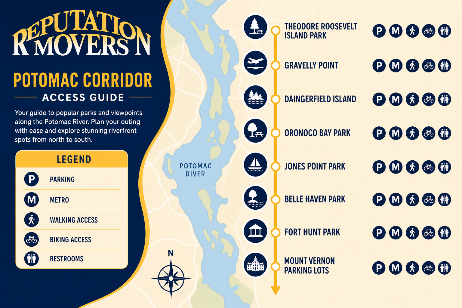
Access is one of the trail’s biggest strengths. You can reach different segments by car, Metro, Amtrak, bike, or on foot from nearby neighborhoods. The official Mount Vernon Trail map identifies major parks, restrooms, parking lots, drinking fountains, and Alexandria’s on-street routing options.
For people comparing Mount Vernon Trail parking or mt vernon trail parking options, the key is choosing an access point that matches the outing. Some lots work well for short family walks, while others are better for longer rides, commuting practice, or a day that combines the trail with Old Town or Mount Vernon.
Most major trail access areas are free, although commercial garages in Old Town Alexandria and some city-managed facilities have standard downtown parking rates. Even if your home is not directly on the trail, a nearby trailhead usually makes it easy to use.
Theodore Roosevelt Island Park: A large access point near the northern end, just north of I-66 on the George Washington Memorial Parkway.
Gravelly Point: Located south of I-395, this is a popular stop for plane-watching near Reagan National Airport.
Daingerfield Island: A useful access point near Slaters Lane for North Old Town, Potomac Yard, and Del Ray residents.
Oronoco Bay Park: A North Old Town access point, with street parking noted on Madison Street.
Jones Point Park: Located at 1 Jones Point Drive under the Woodrow Wilson Bridge, convenient for South Old Town and Hunting Creek.
Belle Haven Park, Collingwood Park, and Fort Hunt Park: Strong southern access points for families, runners, and residents near the Mount Vernon corridor.
Mount Vernon parking lots: The estate’s east parking lot provides free access to the trail, with optional paid entry to the historic estate.
Transit also makes the trail useful for car-lite households. The National Park Service describes the trail as a short walk or ride from Rosslyn, Arlington Cemetery, and Reagan National Airport Metro stations. Braddock Road is also a convenient Metro connection for Alexandria segments, while Amtrak stations in Alexandria and Washington, DC connect visitors to Metro and then to the trail.
How to Use a Mount Vernon Trail Map for Old Town, Mile Markers, and Route Choices
A Mount Vernon Trail map is especially helpful in Alexandria because the trail does not stay as a separated park path the entire way. In Old Town, it merges with city streets, which adds charm but can confuse first-time users.
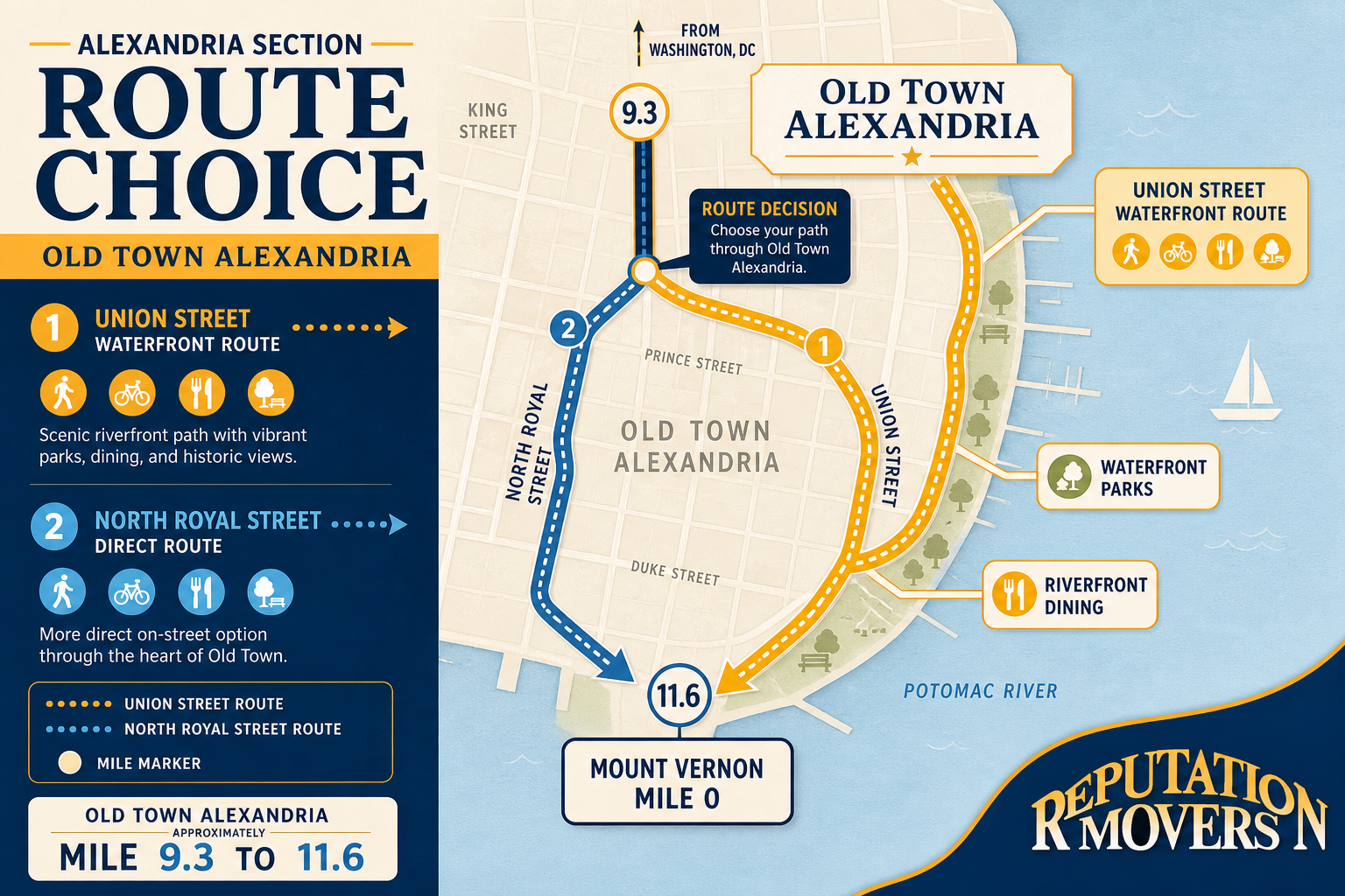
The main Alexandria routing choice is between the waterfront route on Union Street and a more direct option via North Royal Street. Union Street is popular because it stays close to the waterfront, shops, restaurants, and riverfront parks. North Royal Street can be more direct, depending on where you enter or exit the trail.
Mile markers help runners, walkers, and cyclists plan realistic outings. Mount Vernon is mile 0, while Old Town Alexandria sits roughly between mile 9.3 and 11.6. That makes Alexandria a natural middle zone, close enough for northern outings toward Reagan National Airport and Rosslyn or southern trips toward Belle Haven, Fort Hunt, and Mount Vernon.
Before heading out, study where the route changes from off-street path to on-street travel. This matters for cyclists, families with strollers, and runners who want fewer interruptions. Trail resources also recommend checking signs, restrooms, water fountains, and parking locations before starting.
We often see new residents use trail access as a neighborhood filter, especially around North Old Town, South Old Town, Belle Haven, and Fort Hunt. When a move puts you near the right access point, the trail can become part of an everyday routine instead of an occasional weekend destination.
Biking, Walking, Running, Commuting, Families, and Dogs on the Mount Vernon Trail
The Mount Vernon Trail is paved, multi-use, and generally moderate in difficulty. The experience changes by segment. The northern portion between Rosslyn and Alexandria is relatively flat and open, with broad river views and more consistent pavement. The southern eight miles below Alexandria are hillier, more wooded, and include more curves and rougher patches.
For cyclists, the trail is both recreational and practical. It is popular with riders commuting between Alexandria, Arlington, and DC, especially during weekday mornings and evenings. Much of the route is separated from car traffic, but cyclists still need to manage Old Town’s on-street sections and crowded areas like Gravelly Point and the Old Town waterfront.
Walking and running are also strong uses because the trail offers long stretches with minimal road crossings. Many users value the panoramic Potomac River views, DC skyline views, and park access. The path is generally 10 feet wide or more, and Alexandria upgraded a former 4.5-foot sidewalk segment along Abingdon Road to a 10-foot-wide trail in 2025 to improve safety and comfort.
Families and dog owners can enjoy the trail, but planning matters. The National Park Service notes that the corridor is pet-friendly and reminds users to keep dogs leashed and pick up waste. Parks like Belle Haven and Fort Hunt provide grassy areas for children and picnics, while Gravelly Point and Daingerfield Island offer flatter areas for short outings.
Good shared-use habits make the trail safer. Cyclists should yield to pedestrians, announce passes, and ride single-file when crowded. Walkers and runners should stay right and avoid blocking the full path. Dog owners should use short leashes, especially near blind corners, narrow areas, and busy waterfront sections.
Best Scenic Stops, Old Town Restaurants, and Things to Do in Mount Vernon VA
The trail’s scenic value is one reason it anchors Alexandria’s outdoor identity. On the northern half, users get broad views of the Potomac River, the National Mall monuments, and the DC skyline. Theodore Roosevelt Island, Lady Bird Johnson Park, Gravelly Point, and areas near Arlington Cemetery are among the most memorable northern stops.
Gravelly Point is one of the most distinctive local experiences because planes arrive and depart directly overhead at Reagan National Airport. It is popular with families, visitors, and picnickers, so it can be crowded. Still, it shows how closely the trail connects recreation, transportation, and regional landmarks.
Old Town Alexandria adds another layer. The trail runs along Union Street near waterfront parks, dining, shopping, and entertainment. Trail guides note that Gadsby’s Tavern is three blocks up from Union Street on Cameron Street, giving trail users a way to pair a walk or ride with an 18th-century dining experience. The King Street waterfront area, Torpedo Factory Art Center, coffee shops, bakeries, and casual dining spots also make Old Town a natural stop.
South of Alexandria, the trail becomes quieter and more wooded. Belle Haven, Collingwood, Fort Hunt, and the final approach to Mount Vernon offer more parkland and fewer tourist-heavy areas. Jones Point Park adds fishing spots, historical markers, a lighthouse, and views from under the Woodrow Wilson Bridge.
For people searching things to do in Mount Vernon VA, the southern endpoint is a strong full-day destination. Official guidance says the trail runs nearly 18 miles along the river and ends at the estate, where riders can lock bikes and optionally pay to tour George Washington’s mansion and grounds. Without an estate ticket, visitors can still access the Mount Vernon Food Court, open daily from 9 a.m. to 5 p.m., or dine at the Mount Vernon Inn Restaurant.
Seasonal Weather, Safety, Crowds, and Quieter Sections of the Mount Vernon Trail
The Mount Vernon Trail is open year-round from 6 a.m. to 10 p.m., with commuters permitted to use it at any time. Anyone checking weather before heading out should plan around Northern Virginia’s seasonal patterns: hot, humid summers, mild but sometimes icy winters, and changeable spring and fall conditions.

Summer users may prefer shaded southern sections below Alexandria during warmer parts of the day, while northern open areas can feel hotter but offer river breezes. Winter users should watch for ice on bridges, boardwalks, shaded curves, and areas near riverbanks. Spring and fall often bring comfortable temperatures and more trail users.
Safety comes down to surface awareness, etiquette, and planning. The National Park Service notes that the path is paved, but some portions are narrow or close to steep drop-offs and riverbanks. Trail descriptions also note that the southern end can be rougher and hillier, which matters for beginners, children, and anyone attempting a longer ride.
Crowds vary by time and location. The trail is busiest during weekday commuting hours and on weekend mornings and afternoons, especially near Rosslyn, Theodore Roosevelt Island, Gravelly Point, and Old Town Alexandria. Scenic and tourist-heavy areas naturally draw more people.
Quieter experiences are more likely in the southern wooded stretches between Belle Haven, Collingwood, Fort Hunt, and Mount Vernon. Midday on weekdays and early mornings on weekends can also be calmer, particularly away from Old Town and Gravelly Point. If you are new to the trail, start with shorter out-and-back trips from a single park before attempting a long point-to-point ride or run.
One practical note: the phrase thousand trails mt vernon can lead some searchers toward camping-related results, but the Mount Vernon Trail discussed here is the Potomac River multi-use path between Rosslyn, Alexandria, and George Washington’s Mount Vernon. Using official trail maps and local access point names will help you find the correct route, parking, and facilities.
Living Near the Mount Vernon Trail Adds Daily Value in Alexandria and Northern Virginia
The Mount Vernon Trail is more than a paved path. It is a linear park, a commuting option, a scenic route, a visitor experience, and a neighborhood amenity. It helps explain why Alexandria appeals to people who want historic streets, river access, outdoor routines, and regional connectivity in one place.
Living near access points such as Oronoco Bay, Jones Point, Daingerfield Island, Belle Haven, or Fort Hunt can change how residents use their free time. A morning run, bike commute, dog walk, family picnic, Old Town coffee stop, or ride to Mount Vernon can become part of ordinary life. That is why the trail often influences where people choose to rent or buy.
If you are moving to Alexandria, Northern Virginia, or the greater DMV area and want a team that understands the local neighborhoods, access points, and lifestyle details that matter, Reputation Movers is here to help. Get a Quote at https://www.reputationmovers.com/contact-us or Call us today at (703) 660-6683.



























.webp)


.webp)
.webp)
.webp)


.webp)
.webp)













.webp)

.webp)


.png)